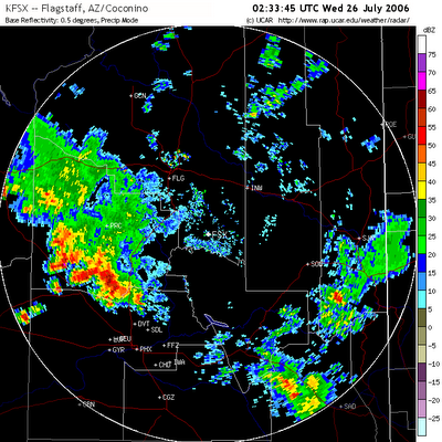
 Yesterday evening, a squall line formed over the Mogollon Rim and propagated towards the south-southwest and covered nearly all of Yavapai County (above image, depicting the radar reflectivity pattern produced by the squall line. Sorry about the wee image , thanks to Blogger. To orient yourself, catch the red line in the upper half which is I40, look for Flagstaff and then move south and west for Prescott).
The thunderstorms were fueled by a low-atmospheric moisture surge from off the Gulf of California that combined with hot and unstable air over Arizona. Behind the squall line, light to moderate rain persisted much of the night, with a few isolated thunderstorms around the area.
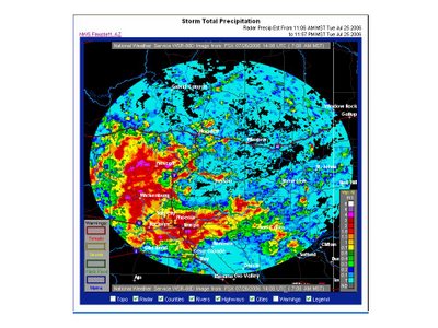
 Most of Yavapai County received over a half inch of rain, with some places receiving up to 4”. (Take a look at the storm total image above, which depicts radar-derived precipitation totals). Prescott Airport received 0.63” and the Embry-Riddle campus received 0.55”.
The squall line continued southward into the Phoenix area, where heavy rain and damaging winds were observed in many areas. Up to 2” of rain fell around the Phoenix area.

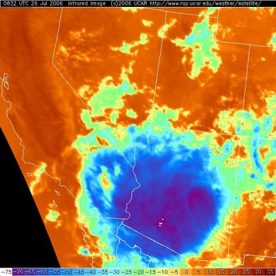
The squall line later joined with other storms moving out of Southeastern Arizona to produce a large cluster called a Mesoscale Convective Complex (MCC). The infrared satellite image above depicts the combined anvil cloud from the storms, which spanned from San Diego to the Four Corners (colder colors on the image indicate higher cloud tops).
This was definitely an impressive storm event!
Today through at least this weekend, a very moist airmass will remain over Arizona and fuel widespread thunderstorm activity. Although the atmosphere is more stable now in the wake of yesterday’s storms, we may still see some strong thunderstorms mainly in the afternoon or evening hours these next couple of days, moving south-southwestward at about 10 mph. The National Weather Service has issued a flash flood watch for Yavapai County for noon today through this evening due to the possibility of heavy rainfall on already saturated soils.
For the record, ERAU offers an undergraduate bachelor-of-science degree program in applied meteorology. They ask that you spread the word to all potential qualified candidates! For more information on the degree program, refer here.
I can attest to the awesome power of that storm here in the Scottsdale area. See my post on the subject.
ReplyDeleteKaren's blog reminded me of that other elephant in the Arizona living room -- Pacific hurricanes. So I checked in at Arizona Weather Talk (see the links at right) to find out that:
ReplyDelete"The influx of low-level moisture, triggered by Tropical Storm Emilia, produced very unstable thermodynamics over much of Arizona yesterday."
Emilia is currently hugging the Baja coast; when Arizona gets a 14-inch rain on the west side of Granite Mountain, it's because a Pacific hurricane spent its last energy and water on our state. This seldom if ever happens in California, by the way. One of those quirks of the weather.
Yipes!
ReplyDeleteThat amount of rain would inundate our streets and likely flood the Susquehanna Valley!
Still, it must have been lovely.
I hasten to add that we don't get the tailend of a Pacific hurricane very often -- the 14 incher I mentioned was in the 80s; the rancher lady at the Bar-U-Bar had to take the Santa Fe into Skull Valley for supplies for a couple of weeks because the roads were too deep in mud to drive!
ReplyDelete