Tomorrow, so I am told, will be dreary with a chance for yet another snow. Reason enough for a yellow post. Already fellow bloggers are posting their own yellows -- predominantly daffodils, but also wild poppies and desert primrose, not to mention early-blooming forsythia.
When I moved, the yellow upholstered furniture was a pleasant surprise, located in a day room in the middle of a long hallway at my new apartment building. Usually, such furniture is covered in rust colors or perhaps plum -- dark and gloomy, but certainly easier to maintain. But I much prefer the yellow; gives my spirits a lift every time I see it.
Wednesday, March 31, 2010
Monday, March 29, 2010
End of an era
This bleak sight is from my Christmas trip down Tucson way. Not really much to say about the graffiti-covered portable sales office out in the midst of a one-time cotton field whose owners thought to cash in on the big real estate boom. That's why they turned off the irrigation -- hence the acreage of dust.
Otherwise, there'd be a covering of desert scrub. Sad.
Linking for Your Pleasure: Geology has produced all kinds of remarkable eye candy, but Rich has a favorite location up near Page that has to be seen to be believed. Also difficult to believe is what can be done, sculpture-wise with the plain old paper plate. Now I know that we have all kinds of folks here in Prescott, but this one really grabbed me: a new local Meet-Up group has been formed to practice the tango, that smouldering Argentinian dance form.
Tuesday, March 23, 2010
Local lion; unknown provenance
If the subject were Barry's birthplace or did that UFO really, really land atop the Washington Monument, I could check in with Snopes. Not so when the email subject is so very local; I can't imagine how the intertubes' resident truth seekers would ever get involved in such a parochial email subject as a mountain lion appearing on someone's doorstoop in Prescott.
In any event, I was among many receiving an email with these excellent pictures. It explained, this big cat's picture was taken a few weeks back right outside of a home in Prescott, Arizona. Our two labs had been barking and doing all sorts of unusual things so we had just opened the door and let them inside. Now we know why they were going crazy. We were about to call someone when the animal disappeared. It took about 24 hrs. for our dogs to get relaxed.
Hoping to get 1) permission to use the photos and 2) possible info about the neighborhood where the cat visited, I did a follow-up email to my source. Turns out I am at the end of a long line of forwards, with no way of knowing the truth.
All I can say is that sightings of pumas happen regularly hereabouts and that the house and surround look as though they might well be in Prescott. And, hey, it's a cool set of pictures!
Saturday, March 20, 2010
Where there's smoke...
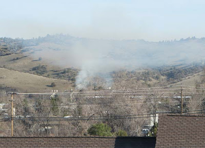
The other morning, I looked out my window on the side of the hill to this sight, part way up the hills to the north of the bowl that holds Prescott. Living in the dry Southwest, smoke is scary. Living where the skies are clear, smoke is very evident, from miles away.
The smoke had already drifted well to the east of its origin. Fortunately, within maybe 20 minutes, the fire was completely out and the air was clearing. A closer shot suggests that whatever was burning was just up the hill from the old officers' houses at Whipple (below).
The Arizona Snow Pack: What an El Nino we've had! Take a look at them purple mountain majesties on this map, representing as they do a big winter for snow in our fair state. I'm told that Flag has had about 10 feet this year, not quite an all time high but almost. See what you've missed by moving to Alaska, dotter?
Tuesday, March 16, 2010
Design on 89
These days, a highway project is not a completed project without the art work. Our new SR69/89 overpass is a good example. According to the Courier, members of the local Yavapai Indian tribe were among those consulted about the designs. "The tribe wanted to show its cultural heritage and the city wanted pine trees," an ADOT spokesman told the paper.
The big circular designs are based upon Yavapai basketwork; I would guess that the frieze along the top represents the pine trees favored by the city fathers.
The deer is the one member of a chase scene on the side of the overpass that I've been able to photograph. The entire lot, best seen driving in from the north, consists of a mountain lion trailing behind the deer, who is following a coyote with a roadrunner out front. Unfortunately, all the designs are on the outside of the structure; if one is motoring into the city from Phoenix on SR 69, none of the artwork is visible!
Friday, March 12, 2010
Siesta
There I was, thinking it might be time for a critter blog ... when what should come my way but an email titled Nap Time, complete with pictures (above, below). Pix from friend Bob. Where were they, I ask. Oh, in our front yard, friend Bob answers. Regular readers already recognize the four as young adult javelina, western hemisphere first (or second) cousin to Eurasia's wild boar. If your property happens to be on a regular route used by a small pack, you might discover a cozy napping spot hollowed out in the ground and, with real luck, occupants.
Tuesday, March 09, 2010
Back in the outback2: Kirkland
The trouble with photojournalism is that sometimes the pictures force the direction of the story. In this case, literally. Simply put, I can't think of a better entrance to the village of Kirkland than this curve in the road heading back to Prescott from Bagdad and the west country of Yavapai County. So be it. If you decide to visit one of the last cowboy bars in these parts, no doubt you'd be coming from the other direction, down from Skull Valley via Iron Springs Road.
Kirkland is important enough as the site of an elementary school serving territory as far away as Walnut Grove and Wilhoit; student population, 59 kids. In fact, as a sometime property owner in that turf, I can tell you that the school district property taxes are higher than in Prescott! An aside: that distinctive mountain in the background of the picture below is, you guessed it, Kirkland Peak.
The Phoenix-Ash Fork railroad line runs through Kirkland, where some maintenance materials are stored alongside the spur tracks.
A pair of small tufa buildings at the intersection of Iron Springs Road and the highway from SR89 is a distinctive sight in Kirkland. The building to the right served as the post office for many years; I've no idea what might be the story of the building to the left. (To any geologists reading this post, I want you to know that I am aware that tufa properly refers to a particular type of limestone deposit, whereas the Kirkland area tufa is actually volcanic tuff. However, locally it is called tufa. There's even a one-time tufa mine up the road a piece.)
My guess would be that most of Kirkland's actual resident population lives in the trailer court; there is only a handful of small houses in town (one of which we almost bought before moving to Arizona).
Focal point of the town -- and an important institution for the entire surrounding area -- the Kirkland bar, cafe, and hotel. It's been some years since I was last in the saloon, but at that time, it was definitely a boondocks cowboy bar, with a dance every Saturday night. The for-sale sign is, I am told, a permanent fixture.
When we moved into Wilhoit back in aught81, there was an arena back of the Kirkland Bar. Periodically, it was used by local cowboys who would get together for an afternoon of roping followed by beer. And, about once a month, parents from nearby ranches held a gymkhana for local kids to show off their horsemanship.
No more. The former arena now serves as one more enclosure for livestock and horseflesh (above, below.)
I'm sure it had to have been during the reign of Ronald Reagan that we landed two new post offices out west of Prescott -- in Skull Valley and in Kirkland (above). After all, our congressional district had faithfully elected and re-elected Republican Bob Stump to the House of Representatives forever and a day.
And here's the road heading back into the hills alongside the Skull Valley Wash and the railroad tracks. First stop, Skull Valley and then Prescott. As I said at the beginning, my pictures dictated the beginning and the end points.
Kirkland is important enough as the site of an elementary school serving territory as far away as Walnut Grove and Wilhoit; student population, 59 kids. In fact, as a sometime property owner in that turf, I can tell you that the school district property taxes are higher than in Prescott! An aside: that distinctive mountain in the background of the picture below is, you guessed it, Kirkland Peak.
The Phoenix-Ash Fork railroad line runs through Kirkland, where some maintenance materials are stored alongside the spur tracks.
A pair of small tufa buildings at the intersection of Iron Springs Road and the highway from SR89 is a distinctive sight in Kirkland. The building to the right served as the post office for many years; I've no idea what might be the story of the building to the left. (To any geologists reading this post, I want you to know that I am aware that tufa properly refers to a particular type of limestone deposit, whereas the Kirkland area tufa is actually volcanic tuff. However, locally it is called tufa. There's even a one-time tufa mine up the road a piece.)
My guess would be that most of Kirkland's actual resident population lives in the trailer court; there is only a handful of small houses in town (one of which we almost bought before moving to Arizona).
Focal point of the town -- and an important institution for the entire surrounding area -- the Kirkland bar, cafe, and hotel. It's been some years since I was last in the saloon, but at that time, it was definitely a boondocks cowboy bar, with a dance every Saturday night. The for-sale sign is, I am told, a permanent fixture.
When we moved into Wilhoit back in aught81, there was an arena back of the Kirkland Bar. Periodically, it was used by local cowboys who would get together for an afternoon of roping followed by beer. And, about once a month, parents from nearby ranches held a gymkhana for local kids to show off their horsemanship.
No more. The former arena now serves as one more enclosure for livestock and horseflesh (above, below.)
I'm sure it had to have been during the reign of Ronald Reagan that we landed two new post offices out west of Prescott -- in Skull Valley and in Kirkland (above). After all, our congressional district had faithfully elected and re-elected Republican Bob Stump to the House of Representatives forever and a day.
And here's the road heading back into the hills alongside the Skull Valley Wash and the railroad tracks. First stop, Skull Valley and then Prescott. As I said at the beginning, my pictures dictated the beginning and the end points.
Sunday, March 07, 2010
Railroad relics
To answer Anil's question, yes, we have some rather cool relics saved from the earlier days of railroading in the Prescott area. Number one, of course, is the actual depot down on Sheldon. Unfortunately, it has never caught on as a proper commercial venue, winding up instead as the office for a big brokerage. However, I'd be willing to bet that one of these days Real Soon Now, a coffee house could make a go of it.
There are the two old small town railroad stations that sit side by side out on Iron Springs Road. The building from Hillside has housed restaurants for some years now, while Drake Station (below) is home to western antiques and memorabilia.
The third station still in service didn't move nearly as far from its original location -- just a few hundred yards from the tracks. It is now part of the Skull Valley museum complex. And well worth a visit (as are the other two station houses.)
We can't overlook the remaining iron work that crosses Granite Creek at the foot of Granite Street and is even visible through the trees from Starbucks at the Depot Marketplace (below). BTW, there's a strange and sad story explaining why the bridge still stands and is now a city landmark.
One More: I had totally forgotten that there is one old rural railroad depot still located at its original site, down in Perkinsville at the end of the Verde River excursion run. Jarart has posted pictures of the old station at Prescott Area Daily Photo.
Friday, March 05, 2010
The Peavine, continued
I'm not the only one fascinated with our railroad history. After discussing plans for my previous post, a friend and neighbor sent me the tables that accompany this post -- thanks, Andy! They deal with various facets of the route, from the big city all the way up to the main line at Ash Fork.
Let's start with the question of elevations. I've turned the table above on its side so that you can read the names of maj0r whistle stops on the line from Phoenix to Ash Fork. It's designed to emphasize the elevation changes that our peavine railroad had to negotiate, starting with Phoenix at 1121 ft. and peaking at Prieta, on the Prescott side of the Iron Springs settlement, at 6148 ft. A bit of a climb!
Here is the stretch from Skull Valley (elev. 4297) on into Prescott (elev. 5370). The old time table showed that it took 1 hr. and 16 minutes to go from Prescott to Skull Valley vs. 1 hr. and 35 min. to climb from Skull Valley to Prescott. Phoenix to Prescott was 6 hr. 5 min but downhill Prescott to Phoenix took only 5 hr. 33 min. Incidentally, the stretch of the right-of-way from Doce to Ramsgate is currently a forest road -- a short outing I recommend; catch it south off Iron Springs Road a mile or so beyond the turn-off to the Iron Springs summer home settlement.
Here's the last of the material given me by the good neighbor -- a picture of all the buildings that made up the Prescott railroad station facilities in 1916. Note that the depot building was actually smack dab in the middle of what would have been Sheldon Street.
My Trip on the Peavine: I'm one of the lucky ones -- I actually traveled from Phoenix to Ash Fork in 1946 on the Santa Fe, leaving the big city about 4:30 PM. Twas a short train, consisting of one box car plus a combo railway express/mail/observation car -- the sort with an open platform at the end of the train, just like you see in pictures of Harry Truman as he made whistle stops when running for reelection. My big disappointment was that it was already dark by the time we headed into the mountains.
Wednesday, March 03, 2010
Mapping the Santa Fe through Prescott
So just where did the railroad go, back in the day when Prescott was served by the Santa Fe? Before I moved, I managed to snag the 1947 15-minute USGS Prescott quad topo, which shows a much smaller town, including the railroad tracks. Scanned and magnified, the topo does a nice job of showing the route. BTW, the tracks are designated by a solid line with periodic cross hatching.
East of the depot down on Sheldon at the foot of Cortez, the tracks headed northeast up through the Whipple Military Reservation -- now the Ft. Whipple VA, then along Granite Creek toward the Dells where the old right of way is now a popular hiking trail.
Here's a snippet of a map I found at the Sharlot Hall web site, a close-up of the area surrounding the station. A couple of fascinating details: two round houses, one for oil tankers ... and the little dam on Butte Creek (right center) which held one of the early city water impoundments. (It's still there, though hard to find as it is completely silted up.)
Less well known is the course of the tracks through the city west of the depot. Basically, it followed Miller Creek briefly, crossed Miller Valley Road at Rodeo Drive to serve the fairgrounds, then headed northwest to Iron Springs Road, which it followed out of town. More or less the same route as Gail Gardner Way, incidentally.
Look behind the espresso shack on Miller Valley Road; you will see that there's a fence on an extreme diagonal which heads southeast behind the Mexican restaurant and the old stone building.
A short distance further south, you will note a little stub of a street on the east, opposite to the road heading to J&G Sales on the west side of Miller Valley. The stub leads to an unnamed bit of street that follows the old railroad course; there was at one time a spur track all the way to J&G's present building (it shows on the map if you look carefully.) As a matter of fact, the iron rails of the spur were still there, embedded in the road surface when we first came to Prescott at the beginning of the '80s.
And the Santa Fe was still stopping in Prescott three days a week at that time. However, the western half of the route had been dropped in the 60s; the trains came and left via the Dells. Reason: railroads had switched to long piggy-back flat-bed rolling stock which could never have negotiated the old winding tracks between Skull Valley and Iron Springs. Drive all the way out to Ramsgate on the Dosie Pit Road and you'll understand!
Subscribe to:
Posts (Atom)