Showing posts with label Verde River. Show all posts

Tuesday, January 01, 2008

The face is familiar

Yes, I realize I am repeating pictures. Most, at least. However, it's for a reason. It's because each reminds me of why Cubism. And because they all remind me of one another.

The top pair are obviously done by a child, in this case my granddotter. Both remind me of the next picture.

This creature -- my wonderful new Eunice the Cat -- was made as a deliberate "primitive" by the Grunge Goddess, a local lady who sells via eBay. So perhaps we can say that cubism is, in part, deliberately child-like.

But then we find this face right out there on a Park Avenue aspen tree trunk for all to see. So isn't it readily apparent that the cubists are really just artists, imitating Nature after all.

The moose? Well, I just included him 1) to honor the kids up in Alaska and 2) because it isn't often you meet up with a plush wall critter who sings when activated by, get this, his very own remote!

Assorted Notes: Lori of Chatoyance has challenged me -- in lieu of a meme tag -- to install a charitable widget to help buy books for a school in Africa. Take a look over at her blog; I'm not sure I'm up to doing the installation. However, I was led by the widget to a most interesting approach to small charitable projects using the Internet, pioneered by FirstGiving. The hows are explained at their site and their blog. In other news, my post about the dead cottonwoods was mentioned in the January Festival of the Trees, hosted this month by Hoarded Ordinaries, which is a blog worth a visit on a regular basis in any event. And, in a final note, remember that elephant that has been sitting in the middle of all the negotiations, planning sessions and plain talk-talk about tapping the Big Chino basin for water? Looks like that elephant is beginning to stir. Big Time. Funny -- when we first moved to the Prescott area, the SRP was never mentioned in the Courier -- almost as if it didn't exist (and own senior water rights to the Verde...)

Thursday, November 08, 2007

Sullivan Lake: Water!

Looking east as Old Hwy. 89 crosses the Verde, bridges dominate. Plus the old lava flow which adds a third layer to the picture. OK, there's also that famous Big Sky for which the west is known.
But the most remarkable feature of our trip yesterday with sheoflittlebrain and E. is directly above: there's water in Sullivan Lake! The last time I saw Sullivan, it was bone dry.

Peer over the bridge railing to see still more water below the dam. A great place for frogs, algae and wild grape vines.

The pools under the old Santa Fe bridge are in the shadows; the petroglyphs are too small to be seen.

Slightly different lighting does make the pools more visible.

Obviously that railroad bridge is a perfect spot for 1) bungee jumping, 2) crossing the canyon on a dare, 3) other mischief. So the powers that be erected barricades at either end out of old rails plus loops of today's ubiquitous razor wire.

Of course, laws and razor wire do little to stop determined litter-atti, who dispose of old bedsprings...

...or harbor the urge to shout loudly in public places.

This particularly objectionable graffiti has been in place since I took pictures a year and a half ago. But despite the encroachment of uncivilization, twas oh so good to see the water!!

Wednesday, November 07, 2007

Believe it or not, a failed development?

What a great day. E & sheoflittlebrain took bro & me out to the Verde headwaters & then we had occasion to explore an interesting Arizona land development. Nearby. One that didn't make the scene. Very unusual in these days of the big boom, just ended.

Here are for sale signs at the point where the road in takes off from Old Hwy. 89.

If I recall correctly, infrastructure (i.e., graded roads) was put in in the late 80s or early 90s. A long, long time ago for Arizona real estate. Then there was some sort of a hassle with the county over water and sewage because of the location vis a vis the headwaters. Don't know the current status. But it sure impeded any housing starts.

The lots are parcels of 5 to 10 acres. Horse property, of course. Well, almost all land outside city limits is horse property; lot sizes are at least 1 acre in some developments and a minimum of 2 acres in most areas.

Plenty of for sale signs. Some of them quite current.

And, as bro found out, also quite pricey -- $490K for 10 acres, according to the flyer he's reading.

Of course, this sign has been around for a while, I'd say.

Now here's one of two parcels that've been developed. A very upscale, prosperous looking, long established horse property, with several animals. Note the dividing line on the hill where grazing on the right has eliminated the grass, which shows up on the left. Believe me, I was very surprised to find that all this land is still lying fallow.

Tuesday, October 16, 2007

The Verde Headwaters

A friend at the Citizens Water Advocacy Group asked me to blog about local rivers yesterday. It was a day on which many bloggers celebrated the environment; I chose the Upper Verde, an area I came to love over the years -- and an area that could well dry up to accommodate the demand for water as population piles into the Prescott region. My computer balked; now that my software has been tamed, I can continue....

The dam at Sullivan Lake. This is the spot where the Verde River officially starts, give or take a few feet. There's a small, narrow canyon at this point. Upstream, the same watercourse is called the Big Chino Wash; at one time in history, it, too, was a running stream.

A mile or so downstream, the canyon deepens and widens...

...revealing a grassy bottomland spread...

...with a line of deciduous trees in the background. These trees mark the spot where the springs begin...

...filling what has come to be called Stillman Lake. My late husband and I walked and climbed this area many times during the late 80s and early 90s. For many, many years, this was a favorite playground for outdoor type families from Chino Valley. The land to the south was still ranch land; it has since been developed. Access was primarily by climbing down one of the little side canyons. For the record, these pictures were taken June 3, 1991; I say this because of the surprising amount of water in the lake (and in June, a dry month.) In visits in later years, it seemed to us that the water level had fallen.
We first ventured down into the canyon from the north rim when we spotted what I always called the "monkey" petroglyphs. Obviously, early Amerinds found this to be a bonnie locale!

We found that there was almost always a signature glyph at the sites we visited over the years. In this case, it was the pregnant deer. Most striking was the glyph above; the art below was placed for visibility from the rim and difficult to photograph. I believe that there is a third preggers animal, but couldn't find any photos in our archives.

The Stillman Lake area is located within a large swath of state land (see map here). It and some parcels downstream have come under management by Arizona Fish and Game, including most of the final mile of Granite Creek as it joins the Verde. F&G is restocking its holdings with native fish; one has to hope that their actions are not in vain. Everybody should take a long look at the Upper Verde before it's too late.

Environmental Tuesday? sheoflittlebrain has proposed that bloggers devote their Tuesday posts to the environment. If that includes my assorted critters and wildflowers, I'll go along with the idea! Anyone else?

Friday, February 09, 2007

Wet Chino, Dry Chino...

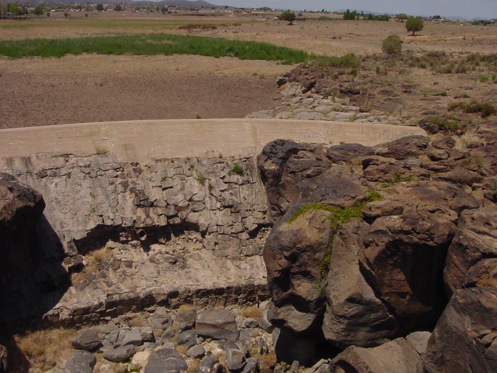
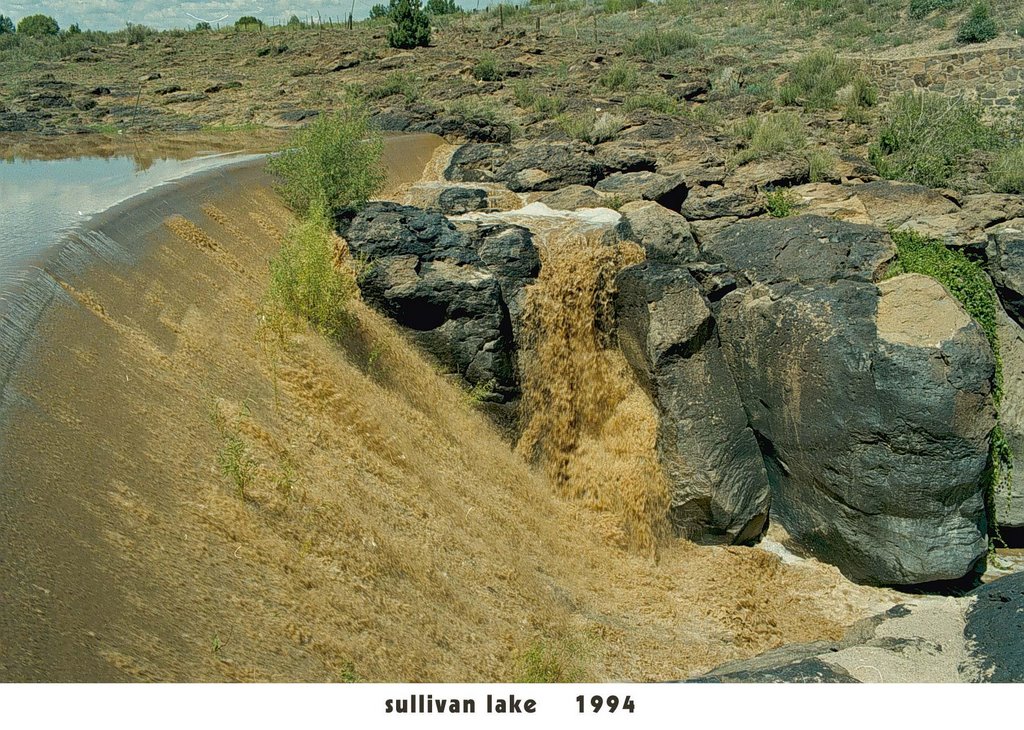
Reading Candace McNulty's latest Verde River article in ReadItHere News reminded me that I had located scans of the Sullivan Lake dam in flood. The picture above was taken last year in July; there is no water to be seen. Nada.

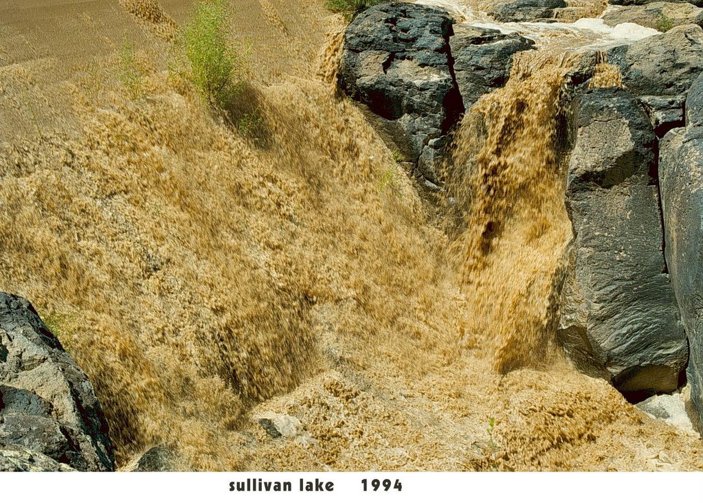
Here's what happens after a really major storm or a big melt in the mountains following heavy snow. (The Big Chino drains everything from Granite Mountain north almost to the edge of the Grand Canyon.) That water, by the way, is several feet above the top of the dam! The roar is deafening; one appreciates the power of water after seeing such a flood.

Note the color of the water -- all that mud is the reason the dam is totally silted up. FYI: the pictures were taken by my late husband in September 1994.

However, this is all surface water -- important way downstream to help fill Horseshoe and Bartlett dams for the people of Phoenix. What matters up in these parts is a major sub-surface basin in the Big Chino.

Getting back to McNulty's article, it's well worth a careful read. She's been writing about the fate of the upper Verde River for several months now. The general upshot is that current plans for Big Chino water by Prescott/PV and Chino Valley will likely dry up the top end of the river. The one factor she misses is that even if the cities were, miraculously, to forego the water ... the spectre of development at the far end of the Big Chino is still leering at us. Fred Ruskin's Yavapai Ranch is likely to be the Next Big Thing in real estate. The water is there, so it will be mined, by one party or another. Too damned bad. It's sometimes called "progress."

Thursday, October 26, 2006

Local Links of the Day

A readers should know by now, I am a fanatic when it comes to the fate of the Upper Verde River. And so today, here's a site that links to most of the critical data concerning the river and the aquifers from which it draws its water. Yes, there is bias: "Compelling evidence shows that future demands on ground water from the Upper Verde Watershed severely threaten the existence of perennial flow in the Upper Verde River as far downstream as Perkinsville," says the opening page. Nonetheless, the links cite all the most recent studies by the USGS and NAU. Local cities are set to spend $30Gs for "review and critique" of the studies, says today's Prescott Courier. Guess what they will find out!

Sunday, October 08, 2006

Link of the Day

Over ten years ago, my husband and I frequently explored a small piece of the Verde River canyon about a mile below the Sullivan Lake dam. An interesting spot: two long pools in the river, rugged canyon walls, a nearly impassable trek up river toward the dam, and splendid petroglyphs (including a repeated theme I called the pregnant elk.) We never got as far east as the confluence of Granite Creek with the river. Too bad; had we realized it, that lush spot is a state game and fish wildlife area open to the public. To find out more about the location, click here. I still have a bid in with friends to take me there one of these days!

Tuesday, August 08, 2006

Ruined Rivers Series

(Note: when I started this blog, my resolution was to avoid the usual blog subjects: politics, Armageddon, the president, war, angst, politics. But there's one serious subject I can't avoid if I want to continue a pleasant existence up in the Arizona mountains -- water...GrannyJ)

Before I pull myself together to work on yesterday/today's blog (my visitors just left for the heat of the Valley and airport fun and games), I must mention the new series running in the Arizona Republic -- "Ruined Rivers," it is called.

If you don't take the Republic, you can see the series (and other background) here. And there's even a water-oriented blog by Shaun McKinnon best accessed from the same site. By all means, read it. The big article is by no means friendly toward Prescott's new water farm up the Big Chino.

And it was apparently written before SunCor's announcement of plans to develop some 15,000 acres of the Yavapai Ranch way up the Big Chino. (So that's why Carol Springer & other folk have been so adamant about widening Williamson Valley Road -- it wasn't the Las Vegas ranch, after all.)

Admittedly, Phoenix has a vested interest in what happens to water upstream. In fact, the Salt River Project tends to get pretty proprietary about the Verde. I don't think they worry too much about Prescott, as such.

But, hey, I love the upper Verde. For instance, have you ever been to Hell Point? It's a beautiful area that hasn't been ruined by tourism or party-ers. Lack of water could do it in pretty fast, though.

I wish the article had given some ideas on how to solve the water vs. developer problem that we face.

Friday, August 04, 2006

Highway Bridges Revisited


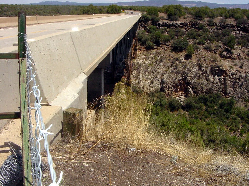
Regular readers may recall my complaint about modern highway bridges -- that they obscure the water course (or any other interesting course, such as Hell Canyon above) from view. And that no one, driver or passenger, can get a glimpse of the water (if any) below. By the way, Hell Canyon does become a very vigorous river during spring melt.


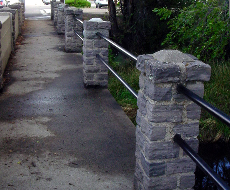
I've had a chance to catch pictures of a couple of examples from the G.O.D. (Good Old Days.) Such as the sidewalk part of the Willis Street bridge across Granite Creek. No problem to see if the water is up. Still, the view is blocked off for cars crossing on the same bridge.


Now here is old-fashioned highway bridge construction at its best -- Old Highway 89 at the Verde River canyon just south of Paulden. The upper crossing is on the old Santa Fe route that went into Prescott.

Friday, July 28, 2006

Picture Drought


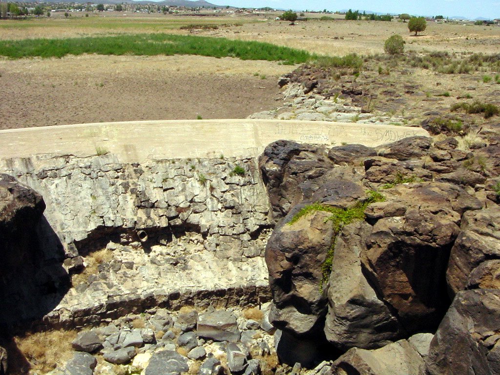
The place: the old dam at Sullivan Lake. It's the point on the map where the Verde River officially begins. On the upside of the dam, the water course is called Big Chino Wash. It's one and the same, the Verde and the Big Chino -- I've always suspected that the fast change of names has something to do with old-time Arizona water politics: ranchers vs. the Salt River Project (which owns the Verde but not the Big Chino.)

Currently, that's beside the point. The photos with this post were taken a week ago, before a couple of big storms up north. I doubt if the storms have changed the picture much. I've never seen it so dry at this dam! Sullivan Lake is absolutely sere. The Little Chino Wash which also flows into Sullivan Lake was devoid of any vegetation; in recent years, it usually supported cattails.


Try to visualize the picture above as one taken from well above the canyon wall. At the right rear is the bottom of the dam. In past years, no matter how dry Sullivan Lake, there's always been a pool of water at the foot of the dam, complete with fish and frogs. Not in our current drought state. The only sign that this is a water course is the grape vine.


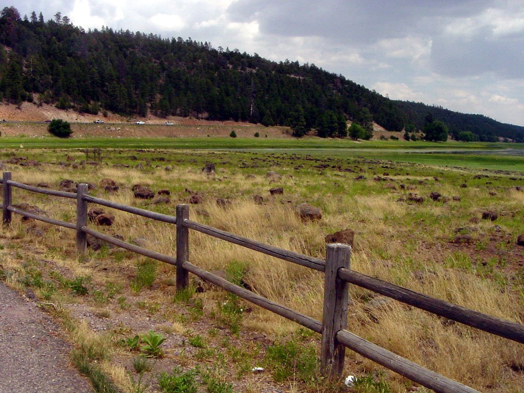
Lower Lake Mary up near Flagstaff isn't nearly as sere as Sullivan. However, the actual "lake" consists of a mere ribbon of water that traces the original route of the creek that feeds the lake. Last year, not only were those fence rails under water, thanks to our wet late winter, but water was actually pouring over the dam.

Friday, June 30, 2006

Bridges As Barriers

Several years ago, the put-down comics had their laugh at the expense of the dry country cowboy. The joke was that the cowboy says to his girl friend, "Hit's been a'rainin' . Why don't we git in the pickup and go down to the river and watch hit run."

Well, I have news for those smart-ass back-east slickers. I've lived in the big city where it rains every other day and I've lived where Spanish moss drips off of the live oaks. But once I returned to Arizona, my water tropism kicked in. These days, there's nothing more wonderful than to go down to the river or the creek or the wash and watch the water run!

That's why I am conducting a one-woman campaign against those absolutely awful cast concrete barriers that line the edges of modern bridges. You can't see a dang thing when you cross the Verde on I-17 Northbound or Kirkland Creek heading to Bagdad or on any modern highway crossing a watercourse.

Look at those cement monstrosities below. They're on the new super duper Willow Creek crossing on Williamson Valley Road. Whether the creek's dry -- or whether it's in flood stage -- you wouldn't find out by glancing out the window. Talk about being disconnected from your environment!


At one time, bridge designers took care to allow passers-by to see that which was being bridged. Take a look at the Verde crossing on I-17 going South as a reminder of a more bountiful day. You can actually see the river on its way to fill the faucets of greater Phoenix.

Even better, consider this bridge over the Verde at Perkinsville. A wonderful old structure that lets the driver know he's up in the air over a Real River. There was a similar bridge over pretty little Kirkland Creek at Yava until a few years ago, when the highway improvers installed the typical concrete barriers that now obscure the creek.


I thank artist Linne Thomas for making a living record of the Perkinsville bridge -- and for letting me use the painting here to illustrate my point. Linne has captured many pieces of the Arizona that is disappearing as the land is subdivided and structures from earlier days are either prettified or bulldozed. You can see more of her work here or in the Arts Prescott co-op gallery on Whiskey Row.
 
Photo Blog Blog Top Sites Blog Directory for Prescott, AZ

Local Blogs - Blog Top Sites