Showing posts with label White Spar. Show all posts

Tuesday, January 06, 2009

White Spar road trip--rain...

Once upon a time, before Eisenhower had invented the interstate highway system, US 89 was a major north-south, border-to-border highway, originating in Arizona, ending at the Montana border with Canada. It was also the only paved road between the southern and the northern halves of Arizona.

The section of route 89, now down-graded to SR-89, most beloved of Harley riders and sports car drivers alike runs through the Bradshaw Mountains, between Wilhoit and Prescott. They like the curves. (If you check the map, you'll see only the major curves.) Today's road trip is a composite of several I've made in the past couple of years and is designed as an introduction only. Hang on to your hat, because it was raining on the first pass!

There! You made it to the pines near Prescott! How many curves? A visiting couple once made the count between Wilhoit and Prescott; their total was over 250, but I think that included the entering and departing ends of each curve. Stay with me. Next, we'll take the trip on a sunnier day (or two).

... or shine; the curves don't go away!

I've mentioned before that one of my uncles worked for ADOT (the highway department) back in the mid-20s when the White Spar was under construction. He later joined the US Forest Service, working all of the forests in Arizona -- except for the Prescott. When he was with the Kaibab and the Coconino, he drove many trips from the north to visit his parents in Phoenix -- all via the White Spar. ("A fine highway," he said, "but look out for scared little old men hugging the mountainside. Extra dangerous when they're heading north -- on the wrong side of the road.") According to his oldest son, they were often delayed for hours in winter by jack-knifed semis completely blocking the roadway. I don't know just when the Skull Valley Road was paved; however, when we moved to Wilhoit in aught-81, almost all semis split off from SR89 at Kirkland Junction over to Kirkland and thence up through Skull Valley, arriving in Prescott via the Iron Springs Road. Not very many curves -- but some long stretches in grade that resulted in trucks gently sliding off the highway.

Now that you've clenched your jaws for your first two rides up the White Spar, you should be used to the curves and we can plan another trip Real Soon Now -- this time to focus on the mountain scenery. (Two other facts worth mentioning: 1) most people are not aware of it, but this highway follows the course of the Hassayampa River for most of its length and 2) my family has the distinction of two speeding tickets on the White Spar, one each for the dotter and my LH. Neither, by the way, on the stretch of road between Prescott and Ponderosa Park, which had a bad rep for tickets.)

Monday, December 22, 2008

White Spar wildfire remains

My LH hated I-17; that's the reason we drove the White Spar so many times over the years to visit my mom when she lived down in Sun City. And I have to grant that all those curves take one through beautiful mountain scenery. Besides, if you drive up I-17, you completely miss the pines as you enter Prescott. (Of course, when I was a kid, SR 89 (then US 89) was the only paved road between Phoenix and US 66 across the top of Arizona -- and considered a very fine highway, indeed.)

Returning from out desert excursion Sunday, the dotter drove us back via the White Spar, which is now a heavy-duty reminder of the 2002 Indian Fire that came within three miles of downtown Prescott. The scenery on both sides of the highway consists of dead snags and downed trees for several miles.

Plus an occasional cluster of trees that survived, but lost their lower branches.

There's only one good change as we wait many years for the trees to grow back -- it is now possible to get a good view of the White Spar mountain for which the road was named. Because the big quartz outcroppings were previously hidden by ponderosas, I had never realized exactly why the road got its name -- even though one of my uncles worked for the highway department back in the aught-20s when the road was built.

Linkables: Remember our last storm? Dagny got a beautiful image of Thumb Butte in the clouds (and from her office window, yet!) And, speaking of photography, here's the URL for the Prescott Camera Club.

Saturday, February 02, 2008

Not your usual Arizona

If all goes according to the soothsayers, we shall have moisture tonight and tomorrow, either as rain or very likely as snow. KNAU was talking one foot of snow for Kingman. Kingman, yet! Surely they were kidding; Kingman doesn't have the necessary elevation. Whatever happens tonight, by late this afternoon, the skies had already turned that chilly grey which precedes Serious Weather.

This is the sort of weather that kept Phoenix in water all those years before the tap on the Colorado River was opened between 1968 and 1993, when the Central Arizona Project canal was finally completed. Previously, almost every drop of water for our great winter playground came from the Arizona mountains.

The mountains are an Arizona that many winter visitors seldom see -- or take seriously. Naifs, they are quite likely to motor up to the Grand Canyon in their golf shorts, only to discover that the rim, at 7000' elevation is as cold as Minneapolis or Chicago or the Dakotas. (The north side of the canyon, another 2000' higher, is not open to the public in winter. If, indeed, they could get in through the deep snow!)

But these pictures, taken on a drive down the White Spar last weekend, show our mountains as they are not often seen, even by locals! As a rule, our heavy weather shows up, does its raining or snowing and moves on; almost immediately, we enjoy sunshine even as we shiver. If it weren't for the shade of forest and hillside, the snow wouldn't last long enough to fill the reservoirs later in the season. The drive was lonely -- few cars had ventured out -- and it was quite other-worldly!

Friday, July 20, 2007

OK, Yellow Is for Safety!

Another of those spooky, serendipitous moments! Early this afternoon, an old buddy gave me a ring. He had just come up the White Spar* on his bike. Was I home?

And so he showed up. On his yellow Kawasaki. What's with the yellow, I ask. It's very visible, says the buddy, as he takes off helmet and other black and yellow safety gear.

I should have figured -- after all, didn't I just post all those yellow warning signs? Two plus two, you know.

Anyhow, here is buddy, looking like a yellow jacket hornet as he gets ready to take off.

*The White Spar Road, for those of you who don't know the area, is the old mountain route into Prescott. It is a fine 15-mile road with a couple hundred curves, beloved of bikers. Some day I'll write about it.

Saturday, November 11, 2006

Yesterday's Bikes

Being as how Prescott is a beautiful little mountain city, it follows that there might be some interesting highways to reach it. And indeed there are. In particular, there's the White Spar (named after either a mine way outback or a great big white quartz outcropping on a mountainside in the Prietas.) Our visitors tried counting the turns in the 12 mile stretch coming into town one time. Two hundred & thirty. I don't remember if that counted those U's going in and out of big folds in the mountain as one or two curves. Anyhow, you can imagine how such a road would appeal to bikers. We get a lot of them.

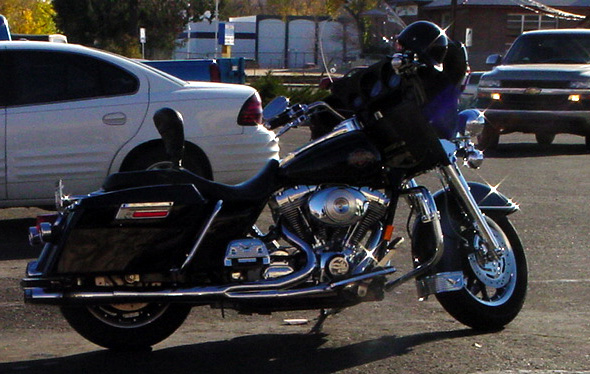
Not to mention those who live here. This fine chrome was parked over at Hastings. Is the owner in for video, book or game?

Also at Hastings, this brushed metal model. I trust that the owner is named Buren or Dyke or Halen or Helsing. Otherwise, he/she is parked where he/she doesn't belong.

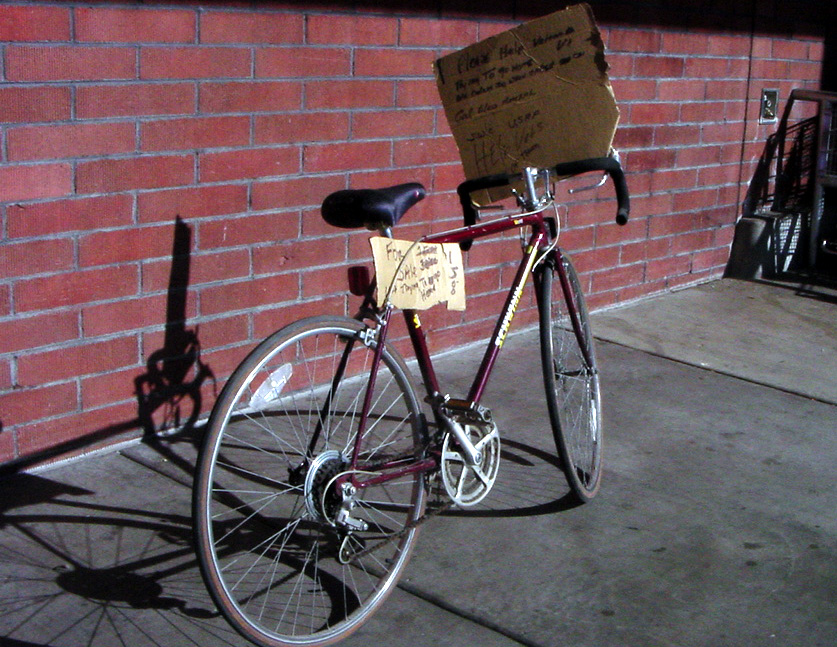
Speaking of what belongs where and to whom, I saw this many-speed real bike for sale over by Albertson's. The signs pleaded for money so a vet could go home. Then I saw the putative vet. I wonder where he ripped off this set of wheels.
 
Photo Blog Blog Top Sites Blog Directory for Prescott, AZ

Local Blogs - Blog Top Sites