Sorry. I got caught up in combing through my photo file looking for interesting fences, the time passed as it will, and it's much to late to open PhotoShop for a session. So: links and notes.
#1 -- The Courier discovered the missing Muffler Man, whom they are calling Big Johnson. Good details about his history -- plus a picture of the cowboy hat.
#2 -- Inasmuch as the dotter is up in Alaska in the Mt. Redoubt volcano territory, I've been following the eruptions. The Alaska Volcano Observatory has a set of fine photos, the best being the night shots with lightening dancing around the peak and the ash column.
#3 -- A blog controversy has erupted up in that cold, northern territory, too, having to do with anonymous political commentary -- and a local politician outing the offending blogger. The dotter gives one account, incidentally explaining her reasons for blogging anonymously; the blogger tells her story as well. Many of my readers may not agree with the politics of the people involved; on the other hand, having lived in a world (Chicago) where complex local ordinances are designed to make almost any ordinary property-owning citizen a potential law breaker, I can understand the desire to keep one's profile low. (BTW, the federal IRS rules & regulations would appear to be closing in on the Chicago standard, to judge from recent shenanigans in DC.)
Showing posts with label volcanoes. Show all posts
Showing posts with label volcanoes. Show all posts
Saturday, March 28, 2009


Sunday, November 18, 2007
Arizona Hot Spot
When your daughter and family move to a house situated smack dab on the Pacific Rim of Fire, you can bet you're going to be interested in volcanoes. Of course, I've been intrigued by volcanoes for many years; in fact, I put the Kamchatka Peninsula on my list of remarkable places in the world I'd like to visit but never will.
 And so it was that I joined the crowd at the Sharlot Hall Museum this afternoon to hear Wendell Duffield's quite informative lecture on Northern Arizona volcanoes. More specifically, the San Francisco volcanic field surrounding Flagstaff. Full house -- people in Prescott are interested in the subject. After all, we have a couple of tired old relics in the area and lava flows here and there, even in town.

 Admittedly, Yavapai County, with its odds and ends of vulcanism, isn't going to interest geologists when next door there's an incredible field of mountains and cones. Every one of those dots on the map above is a volcanic eruption of some sort; the current count is over 600, dating from 6 million years ago up to 1250 AD. And, no, the field is not dead; it is moving to the northeast at the rate of about 2 inches per year and could spring into action one of these days. It is sufficiently un-dormant that Duffield was part of a US Geological Service team who recommended it as a potential source for geothermal energy.
 Flagstaff is located at the foot of San Francisco Mountain, at roughly 12,600 ft. tall the high spot in Arizona. Presumably it was a stratovolcano that blew out its side about one million years ago, a la Mt. St. Helens. Probably a good 16,000 ft. in elevation before the big event. Incidentally, Duffield pointed out that the mound in the lower right dates from only about 400,000 years ago.
 Here's another feature of the field, in a Landsat image. The black cone is SP crater, with a major lava flow to the north. Don't miss all the volcanic cones at the bottom of the image.
 Two types of mountain projected at the lecture. The illustrations are from a book written by the speaker.

 Here is evidence to remind us of the recency of vulcanism in Arizona -- Indian corn left an imprint in a piece of lava found near Sunset Crater, our latest volcano. But even more intriguing is the pottery shard embedded in lava (below) from the most recent flow from a cone at the foot of remote Mt. Trumbull, which is located at the west end of Grand Canyon Natl. Park on the north rim. Both these relics are believed to be in the same age range, said Duffield.
 Judging from the questions the audience threw at the speaker, there's really a lot of interest in local vulcanism, which doesn't make it into most discussions, such as these from the US Geological Service (here and here.) Of course I bought a copy of Duffield's book, Volcanoes in Northern Arizona. And one of these days I might pull together a post about a few of the volcanic features of our local area.
 And so it was that I joined the crowd at the Sharlot Hall Museum this afternoon to hear Wendell Duffield's quite informative lecture on Northern Arizona volcanoes. More specifically, the San Francisco volcanic field surrounding Flagstaff. Full house -- people in Prescott are interested in the subject. After all, we have a couple of tired old relics in the area and lava flows here and there, even in town.

 Admittedly, Yavapai County, with its odds and ends of vulcanism, isn't going to interest geologists when next door there's an incredible field of mountains and cones. Every one of those dots on the map above is a volcanic eruption of some sort; the current count is over 600, dating from 6 million years ago up to 1250 AD. And, no, the field is not dead; it is moving to the northeast at the rate of about 2 inches per year and could spring into action one of these days. It is sufficiently un-dormant that Duffield was part of a US Geological Service team who recommended it as a potential source for geothermal energy.
 Flagstaff is located at the foot of San Francisco Mountain, at roughly 12,600 ft. tall the high spot in Arizona. Presumably it was a stratovolcano that blew out its side about one million years ago, a la Mt. St. Helens. Probably a good 16,000 ft. in elevation before the big event. Incidentally, Duffield pointed out that the mound in the lower right dates from only about 400,000 years ago.
 Here's another feature of the field, in a Landsat image. The black cone is SP crater, with a major lava flow to the north. Don't miss all the volcanic cones at the bottom of the image.
 Two types of mountain projected at the lecture. The illustrations are from a book written by the speaker.

 Here is evidence to remind us of the recency of vulcanism in Arizona -- Indian corn left an imprint in a piece of lava found near Sunset Crater, our latest volcano. But even more intriguing is the pottery shard embedded in lava (below) from the most recent flow from a cone at the foot of remote Mt. Trumbull, which is located at the west end of Grand Canyon Natl. Park on the north rim. Both these relics are believed to be in the same age range, said Duffield.
 Judging from the questions the audience threw at the speaker, there's really a lot of interest in local vulcanism, which doesn't make it into most discussions, such as these from the US Geological Service (here and here.) Of course I bought a copy of Duffield's book, Volcanoes in Northern Arizona. And one of these days I might pull together a post about a few of the volcanic features of our local area.
Wednesday, March 28, 2007
Skull Valley -- a Quick View from the Road
 Getting to Skull Valley is easy. Just turn left onto Iron Springs Road and keep driving. After a few mountains, the highway leaves PNF forest land, the road narrows and downhill on the left is a valley that's green and lush, compared to the sere roadside. The outskirts. Important fact about this ranching community -- it has possibly the best water availability in the whole county.
 Ahead on your right looms a dark, rounded mountain. Volcanic, obviously; mountains built of other kinds of stone (granite, schist or even limestone) display their rocky origins in a muscular way. Do take note of the two dimpled blowout spots. Busy mountain at one time. Very busy.
 Downtown Skull Valley ahead -- the gas station. The only place to gas up between Yarnell and Prescott, by the way. And not on SR89. This is the county road that semi drivers travel to avoid the many "curves and mountain grades" of the White Spar coming up from Wickenburg.
 Downtown includes the cafe, currently closed and on the market. Will someone please buy the cafe; I miss it. When my husband and I first moved to Wilhoit, we almost always breakfasted here. Dick's chili was a great way to start a day of exploration; Helen handled the cowboys, ranchers and outlanders with a fine rural finesse. It was at the cafe that we learned when there would be roping or a gymkhana down at the Kirkland arena. Occasionally a miner from the Copper Basin would drop in with a vial of gold flakes. Oh, yes, bikers from the big, hot valley down south would show up, as well. Not only that, but railroad crews would radio ahead with their orders-to-go and then park their trains to pick up lunch.
 After the disappointment of the closed cafe, heading back into town -- except that a train is coming. Giving me time for a good shot of general store -- #3 of downtown Skull Valley's three buildings. All kinds of special goodies sold here for ranch living and operation.
 I am reminded that, in Prescott, I really miss the trains!

 Admittedly, the modern train, consisting almost entirely of piggy-back trailers, is not nearly as interesting as the old-time mix of box cars, tankers, gondolas, and refrigerator cars, punctuated by the all-important caboose. (Anybody know where all those old cabooses went to retire? Maybe you can buy one on e-Bay...)
 Once the train is gone, we can leave Skull Valley for the drive uphill back to Prescott. There's certainly a lot more to be said about Skull Valley, but not on this short visit. If you are curious, the Sharlot Hall Museum site has some background reading.
Wednesday, January 31, 2007
Mucking Up the Mountainside
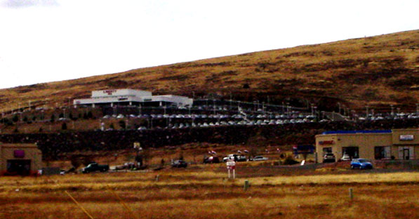 The rise in this picture is the lower, Southeast slope of our very own volcano, Glassford Hill. For most of my years in Prescott, it was a pleasant small mountain, clean, with no man-mades to ruin the prospect. No longer. Prescott Valley can't grow fast enough for its city fathers. So what's wrong with a car dealer up on the mountainside. Good way to get noticed. Especially at night, when the place is all lit up. In fact, it is so bright that a friend and my daughter, independently, call it The Mother Ship. Truly garish, it is.
 In contrast: this huge hillside apartment complex which matches the basalt outcroppings and almost looks as if it might be a monastery. The architect or builder should be congratuated for restraint, tho I'm told that at night, when the tenants all are home from work, the lights do come on.
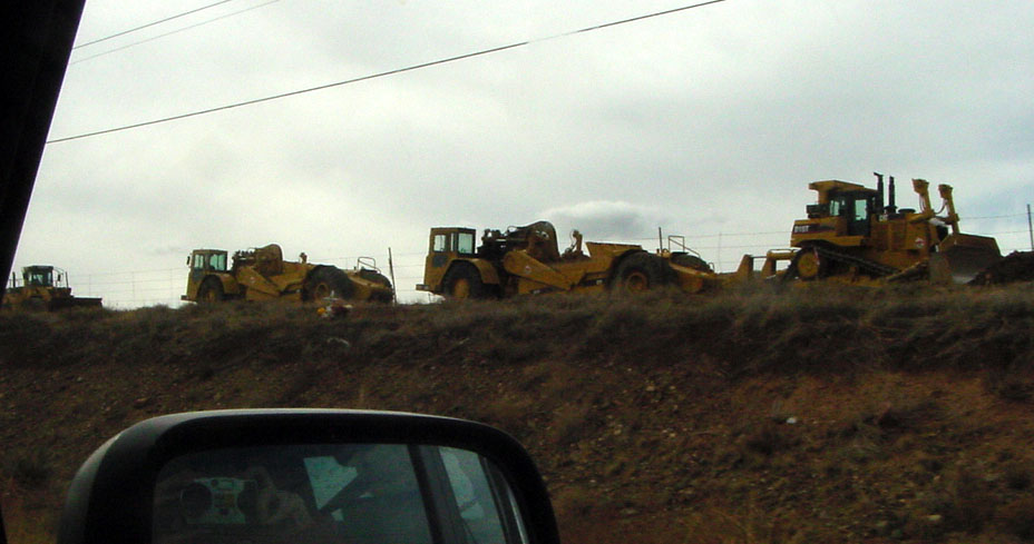 Nearby, a sight that truly makes me shudder -- blades lined up cheek by jowl on both sides of SR69, California-style, ready to flatten more mountain for more shopping center. Just what we need -- lots of sales tax for the government and low-pay retail jobs for the subjects. BTW, I'm not ranting -- just commenting. But take a read of former PV councilman Tom Steele's blog, The Truth Prescott Valley. Might well get your juices worked up. And while I'm on the subject of PV, Steve Words had something to say about a concert at the new arena over east of Glassford Hill.
Monday, November 27, 2006
A Look at Lava...
There's nothing like a road trip to learn a little local geology. Aside from 89A over Mingus Mountain, my favorite earth science lesson is the short climb out of the Verde Valley through the Copper Canyon pass on I-17. Besides, the cuts through the mountain are very pretty, if you like that sort of thing. I do. Returning from my Flagstaff weekend gave me an opportunity to see what kind of photography is possible from the co-pilot's seat in the little green car. It turns out that the shutter is fast enough to let me take pictures from a car moving at highway speeds!
 Take a look at that mesa capped by a lava flow up ahead! That's the elevation we're headed for.
 The wall to the right (above) has a thick layer of grey basalt on top of well baked soil which in turn looks like it is sitting on older lava.
 The obvious lava here is underneath the baked soil. But there must have been lava atop that to cook the dirt!
 This mountain slice appears to include at least three different basaltic episodes, including a flow that filled a major crevice in the older hillside, as outlined by the pink.
 Stripes like these are particularly stunning in the late afternoon or early morning sun. Brings out the red in the one-time soil layer.

 As our car nears the top of the pass, the grey basalt capping the mesas is very evident. Reminds one of gnomes and similar creatures.

 The final road cut at the very top of the pass is missing the lava cap. Either it eroded away or perhaps it never existed!
 These two pictures (above and below) are a reminder that the same sorts of road cuts exist within the Prescott city limits! The traffic light is just beyond the entrance to Costco on SR69, while the picture below immediately precedes the entrance to the WalMart coming from the East. By the way, for a really good look at the rock layers, pop into the WalMart parking lot. Gives you an idea of what Glassford Hill (our local volcano) was up to 14 million years ago.
 The Glassford Hill basalts continue across SR89 south of the Dells and over past Willow Creek Road. If you take a good look at those huge 1.4 billion year old granites of the Dells, you will see that they disappear under the northwestern flank of our volcano.
If all this rock and geologic talk gets to you, Wide World of Maps down in the Valley has a geologic map of Yavapai County. If you go to their site, you might also look for a cool book -- Roadside Geology of Arizona. Or buy the book locally at The Worm or possibly Sharlot Hall Museum store. I also have in my library A Prescott Area Geologic Field Guide for Earth Science Week 1999 which I probably bought at a meeting of the local archeological society; no mention of it by The Google, so I can't recommend a source other than the library.
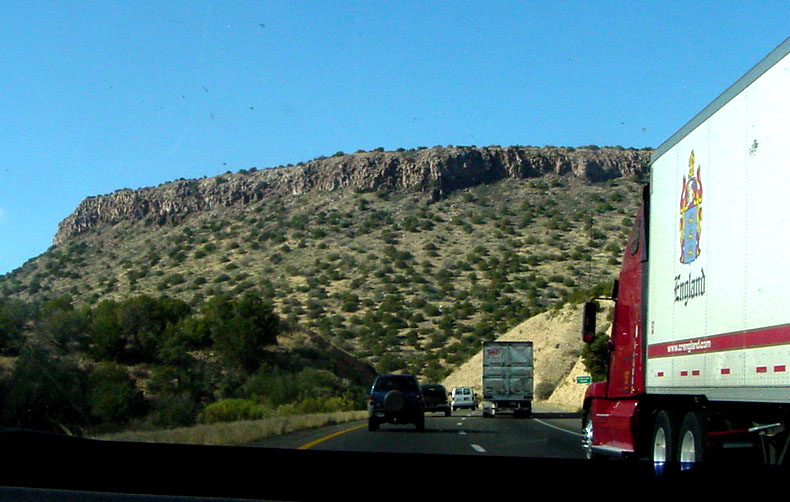 Take a look at that mesa capped by a lava flow up ahead! That's the elevation we're headed for.
 The wall to the right (above) has a thick layer of grey basalt on top of well baked soil which in turn looks like it is sitting on older lava.
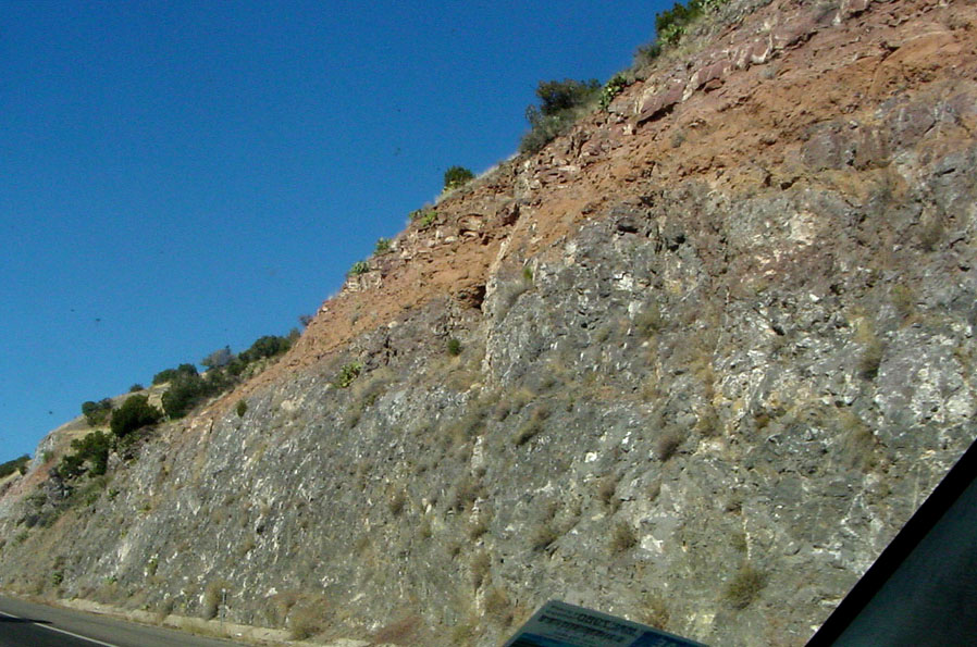 The obvious lava here is underneath the baked soil. But there must have been lava atop that to cook the dirt!
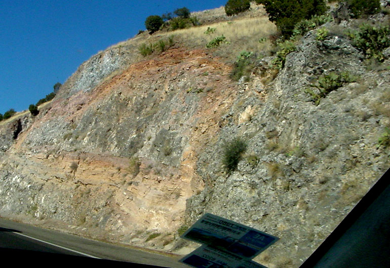 This mountain slice appears to include at least three different basaltic episodes, including a flow that filled a major crevice in the older hillside, as outlined by the pink.
 Stripes like these are particularly stunning in the late afternoon or early morning sun. Brings out the red in the one-time soil layer.

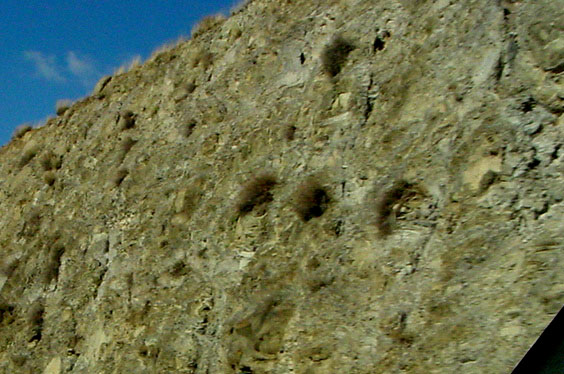 As our car nears the top of the pass, the grey basalt capping the mesas is very evident. Reminds one of gnomes and similar creatures.
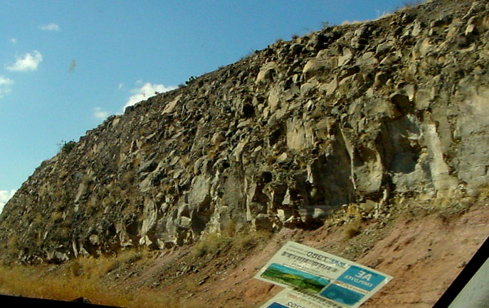
 The final road cut at the very top of the pass is missing the lava cap. Either it eroded away or perhaps it never existed!
 These two pictures (above and below) are a reminder that the same sorts of road cuts exist within the Prescott city limits! The traffic light is just beyond the entrance to Costco on SR69, while the picture below immediately precedes the entrance to the WalMart coming from the East. By the way, for a really good look at the rock layers, pop into the WalMart parking lot. Gives you an idea of what Glassford Hill (our local volcano) was up to 14 million years ago.
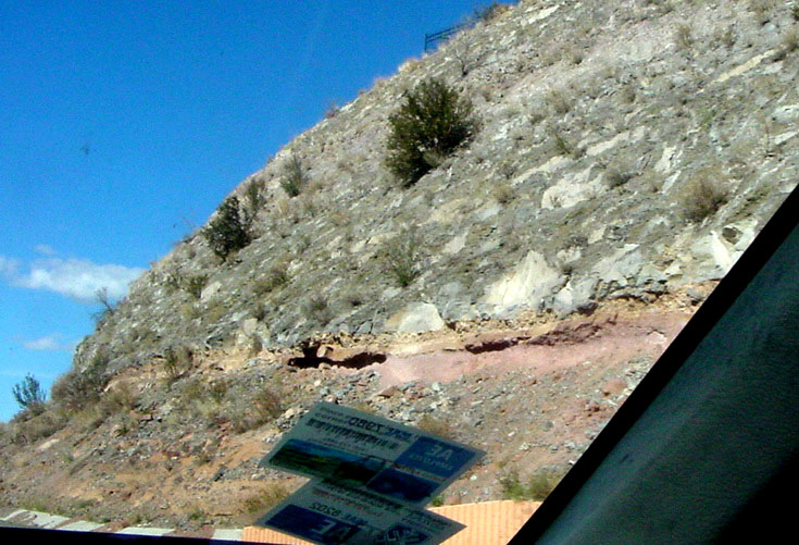 The Glassford Hill basalts continue across SR89 south of the Dells and over past Willow Creek Road. If you take a good look at those huge 1.4 billion year old granites of the Dells, you will see that they disappear under the northwestern flank of our volcano.
If all this rock and geologic talk gets to you, Wide World of Maps down in the Valley has a geologic map of Yavapai County. If you go to their site, you might also look for a cool book -- Roadside Geology of Arizona. Or buy the book locally at The Worm or possibly Sharlot Hall Museum store. I also have in my library A Prescott Area Geologic Field Guide for Earth Science Week 1999 which I probably bought at a meeting of the local archeological society; no mention of it by The Google, so I can't recommend a source other than the library.
Subscribe to:
Posts (Atom)

 Posts


